I had previously written about the possibility of the Mississippi River changing course. This is to follow up on this issue.
The Old River Control Complex (ORCC) that maintains the flow of water between the Mississippi and the Atchafalaya River is, in many ways, the Achilles Heel of the United States.
More than 600 years ago, the Red River in Louisiana and the Mississippi River ran on parallel courses. Sometime in the 15th Century, the course of the Mississippi changed, throwing a loop (Turnbull's Bend) that intersected with the Red River. The result was that water from the Red River began flowing into the Mississippi, but some water still flowed into the lower Red River (now called the Atchafalaya River) which became a distributary of the Mississippi. In the late 18th Century, the entrance to the Atchafalaya River was occluded by a log jam. In 1831, a canal was dug to bypass Turnbull's Bend. The northern part of the bend filled with sediment, but the lower part of the bend (now called the Old River) remained open, connecting the three rivers.
 |
| (Source) |
.
 |
| (Source) |
In 1973, heaving flooding along the Mississippi threatened to undermine part of the Low Sill Structure. As this New Yorker article describes:
After the Corps dammed Old River, in 1963, the engineers could not just walk away, like roofers who had fixed a leak. In the early planning stages, they had considered doing that, but there were certain effects they could not overlook. The Atchafalaya, after all, was a distributary of the Mississippi—the major one, and, as it happened, the only one worth mentioning that the Corps had not already plugged. In time of thundering flood, the Atchafalaya was used as a safety valve, to relieve a good deal of pressure and help keep New Orleans from ending up in Yucatán. The Atchafalaya was also the source of the water in the swamps and bayous of the Cajun world. It was the water supply of small cities and countless towns. Its upper reaches were surrounded by farms. The Corps was not in a political or moral position to kill the Atchafalaya. It had to feed it water. By the principles of nature, the more the Atchafalaya was given, the more it would want to take, because it was the steeper stream. The more it was given, the deeper it would make its bed. The difference in level between the Atchafalaya and the Mississippi would continue to increase, magnifying the conditions for capture. The Corps would have to deal with that. The Corps would have to build something that could give the Atchafalaya a portion of the Mississippi and at the same time prevent it from taking all. In effect, the Corps would have to build a Fort Laramie: a place where the natives could buy flour and firearms but where the gates could be closed if they attacked.
Ten miles upriver from the navigation lock, where the collective sediments were thought to be more firm, they dug into a piece of dry ground and built what appeared for a time to be an incongruous, waterless bridge. Five hundred and sixty-six feet long, it stood parallel to the Mississippi and about a thousand yards back from the water. Between its abutments were ten piers, framing eleven gates that could be lifted or dropped, opened or shut, like windows. To this structure, and through it, there soon came a new Old River—an excavated channel leading in from the Mississippi and out seven miles to the Red-Atchafalaya. The Corps was not intending to accommodate nature. Its engineers were intending to control it in space and arrest it in time. In 1950, shortly before the project began, the Atchafalaya was taking thirty per cent of the water that came down from the north to Old River. This water was known as the latitude flow, and it consisted of a little in the Red, a lot in the Mississippi. The United States Congress, in its deliberations, decided that “the distribution of flow and sediment in the Mississippi and Atchafalaya Rivers is now in desirable proportions and should be so maintained.” The Corps was thereby ordered to preserve 1950. In perpetuity, at Old River, thirty per cent of the latitude flow was to pass to the Atchafalaya.
The device that resembled a ten-pier bridge was technically a sill, or weir, and it was put on line in 1963, in an orchestrated sequence of events that flourished the art of civil engineering. The old Old River was closed. The new Old River was opened. The water, as it crossed the sill from the Mississippi’s level to the Atchafalaya’s, tore to white shreds in the deafening turbulence of a great new falls, from lip to basin the construction of the Corps. More or less simultaneously, the navigation lock opened its chamber. Now everything had changed and nothing had changed. Boats could still drop away from the river. The ratio of waters continued as before—this for the American Ruhr, that for the ecosystems of the Cajun swamps. Withal, there was a change of command, as the Army replaced nature.
* * *
After going on line, in 1963, the control structures at Old River had to wait ten years to prove what they could do. The nineteen-fifties and nineteen-sixties were secure in the Mississippi Valley. In human terms, a generation passed with no disastrous floods. The Mississippi River and Tributaries Project—the Corps’ total repertory of defenses from Cairo, Illinois, southward—seemed to have met its design purpose: to confine and conduct the run of the river, to see it safely into the Gulf. The Corps looked upon this accomplishment with understandable pride and, without intended diminution of respect for its enemy, issued a statement of victory: “We harnessed it, straightened it, regularized it, shackled it.”
Then, in the fall of 1972, the winter of 1973, river stages were higher than normal, reducing the system’s tolerance for what might come in spring. In the upper valley, snows were unusually heavy. In the South came a season of exceptional rains. During the uneventful era that was about to end, the Mississippi’s main channel, in its relative lethargy, had given up a lot of volume to accumulations of sediment. High water, therefore, would flow that much higher. As the spring runoff came down the tributaries, collected, and approached, computers gave warning that the mainline levees were not sufficient to contain it. Eight hundred miles of frantically filled sandbags were added to the levees. Bulldozers added potato ridges—barriers of uncompacted dirt. While this was going on, more rain was falling. In the southern part of the valley, twenty inches fell in a day and a half.
At Old River Control on an ordinary day, when the stilling basin sounds like Victoria Falls but otherwise the country is calm and dry—when sandy spaces and stands of trees fill up the view between the structure and the Mississippi—an almost academic effort is required to visualize a slab of water six stories high, spread to the ends of perspective. That is how it was in 1973. During the sustained spring high water—week after week after week—the gathered drainage of Middle America came to Old River in units exceeding two million cubic feet a second. Twenty-five per cent of that left the Mississippi channel and went to the Atchafalaya. In aerial view, trees and fields were no longer visible, and the gated stronghold of the Corps seemed vulnerable in the extreme—a narrow causeway, a thin fragile line across a brown sea.
The Corps had built Old River Control to control just about as much as was passing through it. In mid-March, when the volume began to approach that amount, curiosity got the best of Raphael G. Kazmann, author of a book called “Modern Hydrology” and professor of civil engineering at Louisiana State University. Kazmann got into his car, crossed the Mississippi on the high bridge at Baton Rouge, and made his way north to Old River. He parked, got out, and began to walk the structure. An extremely low percentage of its five hundred and sixty-six feet eradicated his curiosity. “That whole miserable structure was vibrating,” he recalled in 1986, adding that he had felt as if he were standing on a platform at a small rural train station when “a fully loaded freight goes through.” Kazmann opted not to wait for the caboose. “I thought, This thing weighs two hundred thousand tons. When two hundred thousand tons vibrates like this, this is no place for R. G. Kazmann. I got into my car, turned around, and got the hell out of there. I was just a professor—and, thank God, not responsible.”
... The water was plenty high as it was, and continuously raged through the structure. Nowhere in the Mississippi Valley were velocities greater than in this one place, where the waters made their hydraulic jump, plunging over what Kazmann describes as “concrete falls” into the regime of the Atchafalaya. The structure and its stilling basin had been configured to dissipate energy—but not nearly so much energy. The excess force was attacking the environment of the structure. A large eddy had formed. Unbeknownst to anyone, its swirling power was excavating sediments by the inflow apron of the structure. Even larger holes had formed under the apron itself. Unfortunately, the main force of the Mississippi was crashing against the south side of the inflow channel, producing unplanned turbulence. The control structure had been set up near the outside of a bend of the river, and closer to the Mississippi than many engineers thought wise.
On the outflow side—where the water fell to the level of the Atchafalaya—a hole had developed that was larger and deeper than a football stadium, and with much the same shape. It was hidden, of course, far beneath the chop of wild water. The Corps had long since been compelled to leave all eleven gates wide open, in order to reduce to the greatest extent possible the force that was shaking the structure, and so there was no alternative to aggravating the effects on the bed of the channel. In addition to the structure’s weight, what was holding it in place was a millipede of stilts—steel H-beams that reached down at various angles, as pilings, ninety feet through sands and silts, through clayey peats and organic mucks. There never was a question of anchoring such a fortress in rock. The shallowest rock was seven thousand feet straight down. In three places below the structure, sheet steel went into the substrate like fins; but the integrity of the structure depended essentially on the H-beams, and vehicular traffic continued to cross it en route to San Luis Rey.
Then, as now, LeRoy Dugas was the person whose hand controlled Old River Control—a thought that makes him smile. “We couldn’t afford to close any of the gates,” he remarked to me one day at Old River. “Too much water was passing through the structure. Water picked up riprap off the bottom in front, and rammed it through to the tail bed.” The riprap included derrick stones, and each stone weighed seven tons. On the level of the road deck, the vibrations increased. The operator of a moving crane let the crane move without him and waited for it at the end of the structure. Dugie continued, “You could get on the structure with your automobile and open the door and it would close the door.” The crisis recalled the magnitude of “the ’27 high water,” when Dugie was a baby. Up the valley somewhere, during the ’27 high water, was a railroad bridge with a train sitting on it loaded with coal. The train had been put there because its weight might help keep the bridge in place, but the bridge, vibrating in the floodwater, produced so much friction that the coal in the gondolas caught fire. Soon the bridge, the train, and the glowing coal fell into the water.
One April evening in 1973—at the height of the flood—a fisherman walked onto the structure. There is, after all, order in the universe, and some things take precedence over impending disasters. On the inflow side, facing the Mississippi, the structure was bracketed by a pair of guide walls that reached out like curving arms to bring in the water. Close by the guide wall at the south end was the swirling eddy, which by now had become a whirlpool. There was other motion as well—or so it seemed. The fisherman went to find Dugas, in his command post at the north end of the structure, and told him the guide wall had moved. Dugie told the fisherman he was seeing things. The fisherman nodded affirmatively.
When Dugie himself went to look at the guide wall, he looked at it for the last time. “It was slipping into the river, into the inflow channel.” Slowly it dipped, sank, broke. Its foundations were gone. There was nothing below it but water. Professor Kazmann likes to say that this was when the Corps became “scared green.” Whatever the engineers may have felt, as soon as the water began to recede they set about learning the dimensions of the damage. The structure was obviously undermined, but how much so, and where? What was solid, what was not? What was directly below the gates and the roadway? With a diamond drill, in a central position, they bored the first of many holes in the structure. When they had penetrated to basal levels, they lowered a television camera into the hole. They saw fish.
So, what would have been the impact if the structure had failed?
Well, prior to the construction of the structure, the concern was a natural change in course would leave New Orleans high and dry and destroy the valuable petro-industry in the area. Again, from the New Yorker article cited earlier:
The consequences of the Atchafalaya’s conquest of the Mississippi would include but not be limited to the demise of Baton Rouge and the virtual destruction of New Orleans. With its fresh water gone, its harbor a silt bar, its economy disconnected from inland commerce, New Orleans would turn into New Gomorrah. Moreover, there were so many big industries between the two cities that at night they made the river glow like a worm. As a result of settlement patterns, this reach of the Mississippi had long been known as “the German coast,” and now, with B. F. Goodrich, E. I. du Pont, Union Carbide, Reynolds Metals, Shell, Mobil, Texaco, Exxon, Monsanto, Uniroyal, Georgia-Pacific, Hydrocarbon Industries, Vulcan Materials, Nalco Chemical, Freeport Chemical, Dow Chemical, Allied Chemical, Stauffer Chemical, Hooker Chemicals, Rubicon Chemicals, American Petrofina—with an infrastructural concentration equalled in few other places—it was often called “the American Ruhr.” The industries were there because of the river. They had come for its navigational convenience and its fresh water.This 2011 article from Forbes states:
The U.S. Army Corps of Engineers is forcing the river down a path it no longer wants to travel. Had the river gotten the best of the engineers in 1973 the Mississippi would not be the same river today–it would have forced a new path down the Atchafalaya basin, a course that is some 20 feet lower than the river’s current main stem, and which offers a 150-mile shorter path to the Gulf of Mexico. Its course has changed dozens of times over the millenia, “sweeping back and forth like a garden hose,” and will change again. You can see a beautiful map of the river’s countless meanders here, and download a full set of historical maps here.
McPhee spent months trying to understand the centuries of engineering prowess that have gone into trying to control the Mississippi, especially the creation of structures much in the news today, like Old River Control and theMorganza Floodway, which was opened over the weekend to allow floodwaters to course down through the Atchafalaya basin.
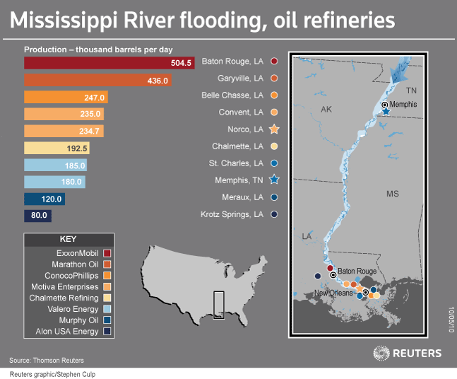
The corps has had a generation to strengthen its defenses since then, but there remains today more than a theoretical chance that 2011 could be the flood where the Mississippi finally decides to go the way it wants to go rather than stays within the bounds that man has chosen for it. Once freed, all the sandbags and bulldozers in the world would be insufficient to put it back where it is. The effect on the U.S. economy of a shift in the Mississippi’s path would be significant. On the river between Baton Rouge and New Orleans sit dozens of industrial sites, processing agricultural products, making chemicals, refining 13% of the nation’s gasoline (see an excellent map of refineries here). Of these, Alon’s Krotz Springs refinery in the Atchafalaya basin is at greatest risk of inundation, while ExxonMobil has closed two pipelines and scaled backproduction at its refinery, the biggest in the region. Upstream in Memphis, Exxon closed a riverside terminal that has “become part of the river.”Americas Wetlands quotes the following from a scholarly journal:
In the aftermath of the huge floods that would cause the main flow of the river to jump to the Atchafalaya River, aside from the cost, anxiety, tragedy, and aggravation of dealing with massive amounts of water being in the wrong place, there would be lingering issues that would change the way of life on the lower Mississippi. Instead of 70% flow down the lower Mississippi and 30% flow down the Atchafalaya, the percentages would probably reverse. The Atchafalaya would be a rushing, raging river, even during the fall for a period of time until it scoured the channel and filled in the lower reaches so that the flow would diminish. Morgan City would have to be relocated, as would other communities and many businesses, possibly including the massive infrastructure of the offshore oil and gas industry. Fisheries would be altered measurably all across the delta. Oyster reefs would be immediately destroyed, and would take several years to reestablish and become productive (no erysters!). It would probably take two decades to adapt to the new environment around present day Morgan City. Additionally, pipelines, bridges, and the like that cross the Atchafalaya would be destroyed or rendered unsafe. The ruptured natural gas pipelines would place stress on fuel supplies for energy companies, but they would quickly change to more costly fuel sources and have little or no interruption of service. Imagine the traffic jams when and if bridges on I-10, U.S. 90, and U.S. 190 collapse (what about the railroads)? All trans-state traffic would have to be rerouted to I-20 via I-55 through Jackson, Mississippi, adding up to 615 miles to the trip (not to mention time delays from the traffic jams). The protective levees of the Atchafalaya Basin would have to be upgraded to handle the new pressure from Spring flows. And, oh my gosh, think of the negative impact on the crawfish supply!
The lower Mississippi would still have a copious amount of water, but it would be slack compared to today. Shipping could continue to be an important industry, but it would be interrupted for a time. The slack water would allow (cause) the thalweg to fill in and stop deep-draft shipping. However, after intensive dredging efforts it may be found that a 50 ft channel can be easily maintained because of the tremendous decrease in sediment. New Orleans, possibly Baton Rouge, and all other cities and towns along the lower Mississippi would no longer be able to get their drinking water from the river. It would become too salty, since the lower fresh water flow would not offset the tidal movement of the Gulf. Can you imagine the cost of piping or trucking enough drinking (and flushing, etc.) water from north of Lake Pontchartrain to supply the needs of Greater New Orleans? Can you imagine Greater New Orleans without water for drinking and sanitation? Even when the water was just barely increasing in salinity, there would be severe damage to water heaters, fire sprinklers, fire truck pumping systems, and more. The quality of our coffee! As mentioned above, the fisheries (especially those associated with the fresh water river) would suddenly change. And what about the massive petrochemical industry corridor? Aside from the impact on shipping, which they could weather over time, industry could no longer use fresh river water for thermo-electric cooling. The saltier water would corrode all the pipes and related instrumentation. Of course, industry would change to salt-tolerant materials, but that would be costly and time consuming. Also, the sugarcane industry would have problems without sufficient fresh water.
All of this adjustment, and we have not delved into the intensity of impact on people=s lives during the crisis and the adjustment period. All normal routines would stop. Businesses would be closed, as would schools, normal government, etc., etc. Virtually the entire population would spend months and months just coping - just putting their and others= lives back together. Imagine the emotional strain to the population - people losing a lifetime of accomplishment. This would be a tragedy of monumental proportions. It would interrupt life much like World War II.
One can also imagine the impact on the nation. Massive use of Federal dollars to protect and restore Louisiana's infrastructure. Loss of natural gas (there would be brown-outs throughout the eastern seaboard). Commerce would be interrupted by restriction of travel and Louisiana's inability to focus on supplying items traditionally demanded from her natural resources by the nation. Prices of all Louisiana products (from the natural resources [fisheries, oil, gas] to industrial products [poly vinyl chloride, polyethelene, etc.]) would soar. The interruption of the pogie fisheries would be very negative for such food industries as chicken, catfish, and hogs (see the last section of the notes). New Orleans is one of the most important ports in the nation, and it would suddenly cease to function; all shipping and related industries on the Mississippi River would stop. International trade would be further imbalanced. The massive fertilizer business would shut down and the agriculture industry would falter.
And what about the economy of south Louisiana? For a period of time, all the revenue would dry up and tourism would collapse. Even Mardi Gras would possibly come to a halt!!! Only the mosquitoes would do well! And probably the cockroaches and Formosan termites.
Long term, we would adapt. Once the drinking and sanitation water issues were resolved, tourism would return. Coastal erosion could be reversed on the west side of the present-day Mississippi River. Shrimp, oysters, and other fisheries would probably flourish after a number of years due to new marshes being produced and nutrient rich sediments being redistributed.
This would obviously place a lot of stress on at least two generations of residents. We would survive, but it would be a new Louisiana and Mississippi River delta.(See also here and here from The Daily Impact).
Flooding is not the only danger to the structure. Two years ago, the Christian Science Monitor reported on the risk of an earthquake to the Mississippi delta region. From that article:
In 1811 and 1812, the New Madrid fault zone that zig zags through five states shook so violently that it shifted furniture in Washington, D.C., and rang church bells in Boston. The series of temblors changed the course of the Mississippi River near Memphis, and historical accounts claim the river even flowed backward briefly.Geologists consider the New Madrid fault line a major seismic zone and predict that an earthquake roughly the magnitude of the Haiti earthquake (7.0 on the Richter scale) could occur in the area during the next 50 years.
That forecast is of particular concern because the New Madrid zone sits beneath one of the country’s most economically distressed areas – the Delta. In many counties in the Mississippi Delta, the poverty level is triple the national average.Moreover, the area is comparatively less prepared to deal with a huge earthquake than are other seismically active areas in the US, says Mark Ghilarducci, vice president of James Lee Witt Associates, a crisis and emergency management consulting company in Washington.
“There have not been enough resources applied for retrofitting that there could be,” Mr. Ghilarducci says. “I would like to see far more retrofit programs, strengthening of buildings, especially masonry buildings, tying down bridges. That builds resiliency in a community.”
... The New Madrid fault zone crosses five state lines and the Mississippi River in at least three places. It extends from northeast Arkansas through southeast Missouri and into western Tennessee, western Kentucky, and southern Illinois.
In the 1800s, few people lived in the region. Today, it is densely populated and includes Memphis and St. Louis.“All the faults are active,” says Haydar Al-Shukri, director of Arkansas Earthquake Center. “We would see an earthquake 10 times larger than the Haitian earthquake or even those in California because of the amount of distance the seismic waves of the earthquake would travel.”
In many areas, people still live in shanties. Healthcare is sparse. Even clean water is scarce in some places. Often, public and private buildings, are decades-old and fragile. They have yet to be retrofitted or strengthened. Hundreds of towns could see severe structural damage, and large segments of the population displaced, Dr. Al-Shukri says.
“You still have a lot of places with cinderblock structures,” he adds. “That is the worst kind of structure you can build in a place with earthquakes. These concrete blocks are very stiff, and they do not have flexibility, so they can’t yield to seismic vibrations.”
The challenges are particularly daunting in rural areas. Given that federal dollars most often target metropolitan areas, people could be cut off from supplies for days. To help mitigate this threat, Memphis Light, Gas & Water was given a grant of $2.6 million to reduce the risk to its electrical grid from earthquakes.“Disasters aren’t entirely a government issue,” Ghilarducci says. “If people live further out, they need to have something to be self-sufficient for a couple of days until help can reach them.”

No comments:
Post a Comment